Scout flies first.
Clears the air.
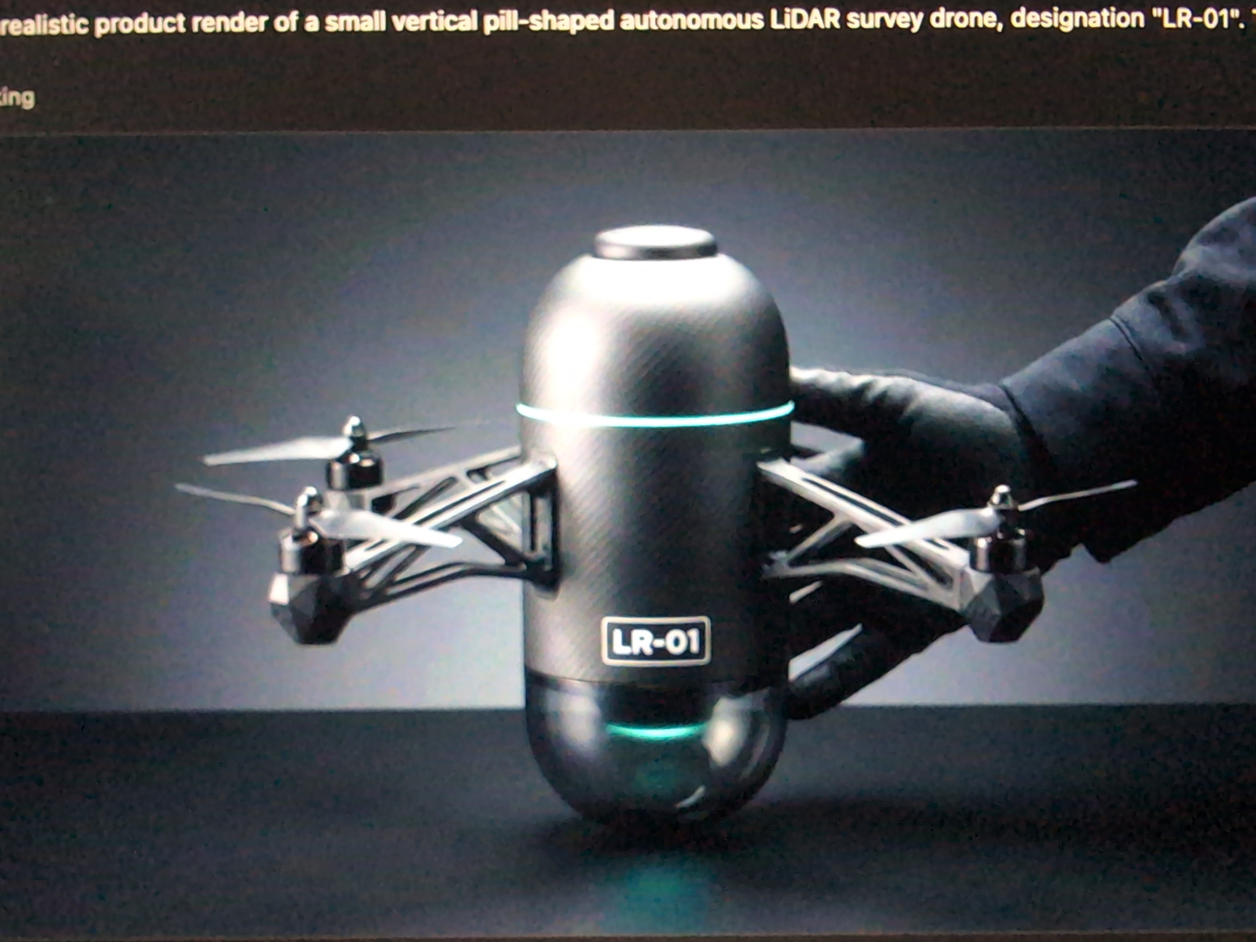
Vertical-capsule airframe, eight coaxial rotors, rotating LiDAR turret. Sweeps the zone, builds the terrain model, hands a cleared corridor to the Probes flying behind it. On-device autonomy — no remote pilot, no ground tether.
Endur Scout
Goes first. Clears the air. Maps the terrain.
Vertical pill-shaped airframe with four lateral arms carrying coaxial-paired rotors. The lower section is a powered turret holding a rotating LiDAR on a slip-ring assembly — the dome spins while the airframe holds course.
- Payload
- Rotating LiDAR · RGB
- Frame
- 3D-printed ABS, weight-optimized
- Rotors
- 8 (4× coaxial pair)
- Battery
- 6× 5000 mAh · 7.4 V · 50 C LiPo (≈ 222 Wh)
- AUW · est.
- ≈ 3.0 kg
- Endurance · est.
- ≈ 15–20 min, full payload
- Comms
- WiFi · LTE · GPS
- Autonomy
- On-device, no remote pilot

Built around the turret
Top: brain. Middle: power + lift. Bottom: a rotating eye.
Three stacked subsystems on a single vertical axis. The upper cap holds the flight computer and antennas. The middle carries the coaxial-rotor arms and battery bay. The bottom is a powered turret — the LiDAR rides on a slip ring so it spins freely while the airframe holds course.
- Compute
- Raspberry Pi + flight controller
- Antennas
- WiFi · GPS · LTE
- Power
- Stacked LiPo · PDB
- Sensor
- Vertical RPLiDAR on turret drive
- Coupling
- Slip ring + ring bearing
- ≈ 3.0 kg
- All-up weight
- Full payload, est.
- 15–20 min
- Endurance
- Per LiPo pack, est.
- 0.05 m
- Surface resolution
- Rotating LiDAR per pass
- 0
- Remote pilots needed
- On-device autonomy
Let us scan your land.
A small number of free reference surveys in 2026 — landowners, ranchers, exploration juniors. You give us permission and ground truth; we tow the trailer out, fly the survey, and hand you the heatmaps.