Landowners · first sites
Scan your land
Curious what's actually under your acreage? We tow the trailer in, fly the survey, and hand you a heatmap. First reference scans are free in 2026.
Request a surveyA towable trailer, two drone classes, one AI brain. Scouts fly first — LiDAR and RGB to clear corridors and map terrain. Probes follow with ground-penetrating geophysics. Overlord assigns zones, phases sorties, and re-plans as data lands.
Geophysics today is slow, destructive, expensive, or coarse. The next survey of your land should arrive on a trailer, fly itself, and land in your inbox as a meter-scale heatmap by week's end.
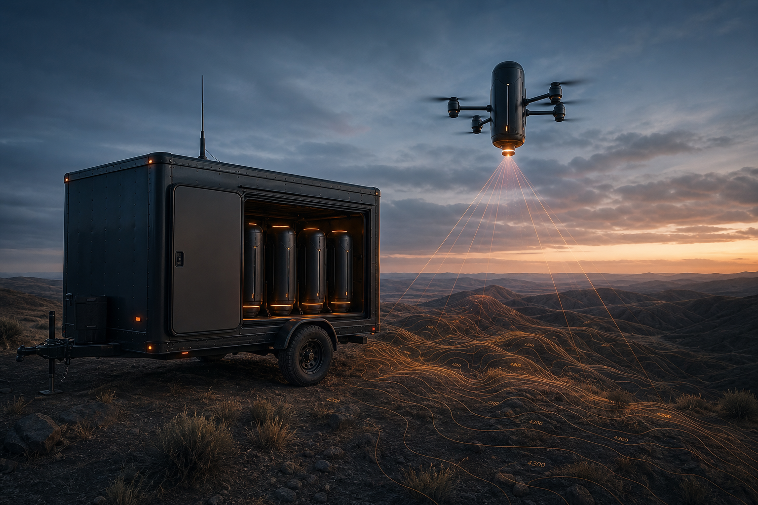
Drive in. Drones up. Heatmap out.
A towable enclosed trailer carrying the whole survey system — drone dock bays with auto-charging LiPo cycling, a local Overlord compute node, LTE / WiFi backhaul, and shore-power or generator input. We tow it to your site, level the trailer, deploy in roughly fifteen minutes, and start flying Scouts.
Goes first. Clears the air. Maps the terrain.
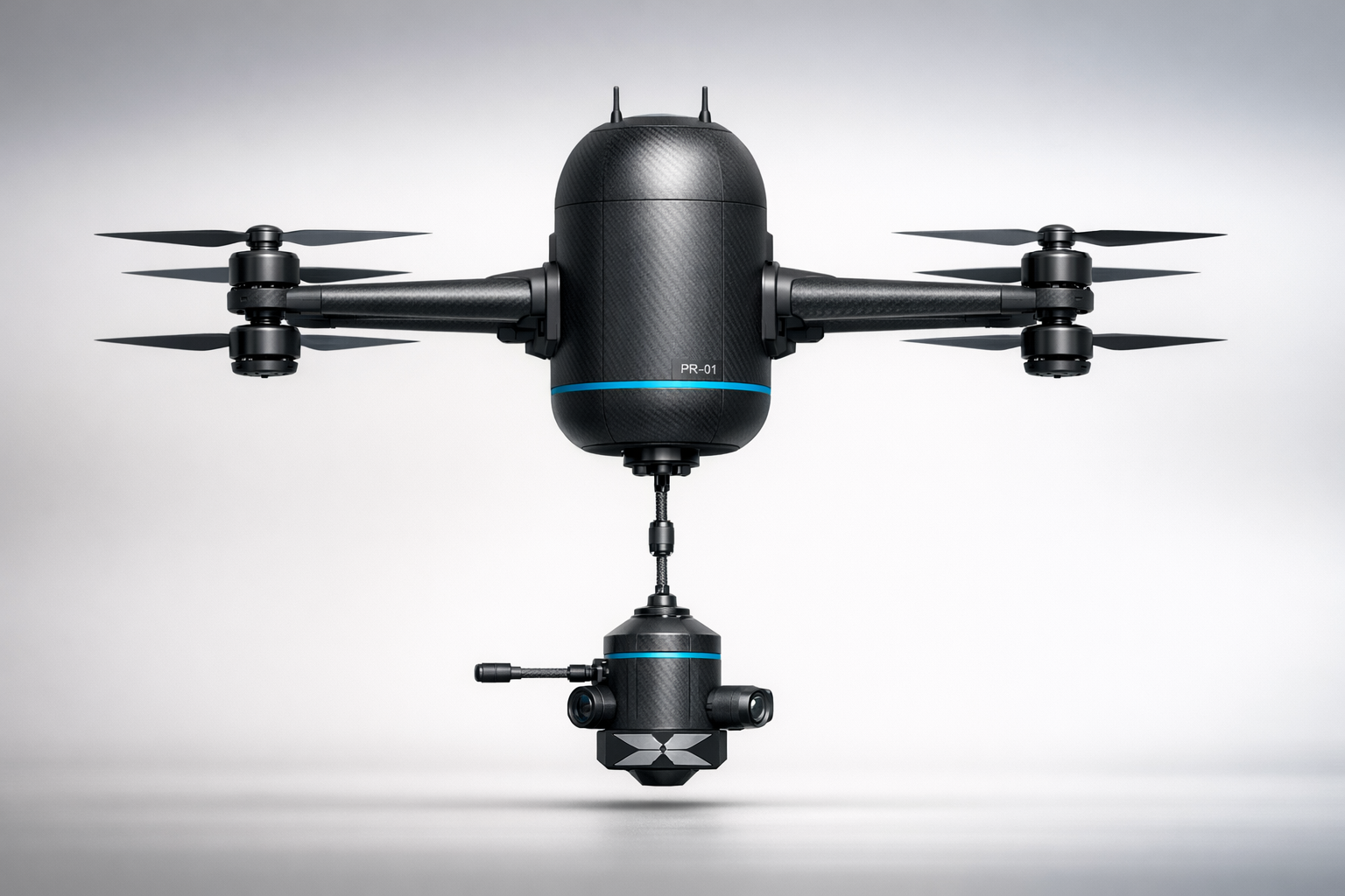
Vertical-capsule airframe with eight coaxial rotors and a gimbaled LiDAR turret on a slip-ring assembly. Sweeps the zone, builds the terrain model, and hands a cleared corridor to the Probes flying behind it.
Follows the corridor. Sees through the surface.
Larger survey airframe carrying ground-penetrating radar, frequency-domain EM, magnetometer, hyperspectral and radiometric payload. Each sensor is multi-frequency and multi-power — frequency picks the resolution, power picks how deep the signal still returns useful contrast. Probes sweep both axes per pass and stack the shallow, mid, and deep returns into one volume.
Scout maps the surface, Probe reads the shallow subsurface, Overlord fuses every pass into one interactive volume — mineral bodies in the 0–10 m FDEM detection band, surface metal finds, and the depth-dependent probable-area footprint. Open the full map to orbit it and see which sensor backs each layer.
Explore the survey map →Interactive concept render from real survey-data structure · not yet flown
Traditional-method values are public benchmarks. Endur values are pre-flight estimates from the current build and will firm up once integration testing completes.
LiDAR point clouds and DEMs the moment Scouts return from a sortie.
Frequency sets resolution, power sets depth. Both axes swept across each flight, then fused into 3D mineralization volumes.
Magnetic, electromagnetic, and hyperspectral anomalies surfaced as you fly.
Every airframe flies itself — no remote pilot, no ground tether.
Overlord splits the site into zones and runs Scouts first, then Probes. It works on a single pair and parallelizes automatically across whatever's in the hangar.
The fleet keeps operating when the link to Overlord drops.
Live point-cloud SLAM running on the Pi-class compute. Builds a real-time obstacle and terrain model as the Scout flies.
Bottom-mounted rotating LiDAR on a slip-ring assembly. Mechanical build complete, scanning verified on the bench.
Standalone MAVLink-based controller bench-running on a parallel airframe.
Merging the perception stack and the flight stack onto one airframe — the current sprint.
Trailer outfit, dock-bay design, LiPo charger array, mission-compute install.
Mission planner and sortie scheduler that runs on the trailer compute, talks to drones and to cloud Overlord.
End-to-end takeoff, autonomous mapping sortie, return-to-dock with battery cycling.
Scaled-up airframe and payload integration for the geophysics sensor stack.
First on-property scan for a landowner partner. Free, in exchange for permission and feedback.
We'd rather show grant officers and first survey partners exactly where we are than claim flight time we haven't logged.
Curious what's actually under your acreage? We tow the trailer in, fly the survey, and hand you a heatmap. First reference scans are free in 2026.
Request a surveyTruck-mounted geophysics and crewed flyovers, replaced by an autonomous fleet that delivers meter-scale resolution at a fraction of the mob/demob cost.
Request a surveyGPS-degraded, subterranean and contested-terrain ISR — same trailer, same airframes, same magnetic-anomaly stack.
Request a briefA small number of free reference surveys in 2026 — landowners, ranchers, exploration juniors. You give us permission and ground truth; we tow the trailer out, fly the survey, and hand you the heatmaps.